When you were a kid, where did you live? Maybe you lived in an apartment in a city, a cottage in the country, or a duplex in mid-town. Me? I lived in a single-family home in the suburbs of unincorporated county land in Tampa Bay, Florida. At first it was okay. My neighbors were two little girls around my age when I was very young. We played every day until they moved away when I was 14, at which point I was very, very alone.
All through middle and high school - seven of my most formative years - I was bused nearly an hour away to go to school. The closest city bus stop was four miles from my house, and my parents hated driving me more than ten minutes away to play with friends, so I had extremely limited friendship options. We lived in a neighborhood with only about ten other homes on a block the size of one-square-mile. The memory of forcing myself up to each neighbor's door, knocking and asking "are there any kids here that want to play?" to amused adults who had nothing to offer but rejection still haunts me.
I was suffocating. I felt like a prisoner wherever I landed. I felt rejection and a deep loneliness which has stayed with me, affecting my ability to function at times. I would often refer to my hometown as a "black hole" from which I had to escape.

And escape I did. I moved to Portland in 2012 and my life was forever changed. Portland is so meticulously planned and the city is rife with civic engagement. Seriously, their comprehensive plan is the size of a fat encyclopedia. They started writing regulation and putting tracks in the ground forty years ago and it shows. I wanted to bring those design principles back with me to my beloved hometown of Tampa Bay, which is in dire need of some intentional urban planning.
For me, sustainable planning principles are not just about ensuring a decent quality of life for some people - they're about justice. Justice for lonely children who like me, are developing mental illnesses like depression and social anxiety out in the suburbs as a result of social isolation. Justice for those whose lives were not considered when roads were built and development approved throughout the past several hundred years. While I was in Portland, Trayvon Martin and Michael Brown were murdered, and the Black Lives Matter movement was born. I learned that racism - segregation, discrimination, and concentrated poverty - is built directly into the land. And it is our job today to do something about it.

I am studying urban planning, transportation/accessibility in particular, because I am working to dismantle systems of oppression that benefit certain individuals in America and keep others at a perpetual disadvantage.
In America, especially in Florida and Tampa Bay, our built landscape is designed around individualistic and cost-prohibitive automobiles. While I'm in the Netherlands, I plan to pay special attention to the ways that ALL people are considered in the construction of their cities and transportation infrastructure. I will be taking notes on how non-automobile modes, such as trains, bikes, buses, and feet, are given equal or priority consideration in design, and how they coalesce into a complete, intuitively navigable system. I have heard that the key to success is mode separation, so one of my goals is to test this theory and observe how they achieve this separation of modes considering high-density space constraints.
I am particularly interested in how the Dutch make accommodations for the disabled members of their society, and if they have any race-based justice issues that are addressed through policy, regulation, and access. I wonder if Dutch neighborhoods are segregated as ours are, and if you can tell when you're in an under-served (read: poor or people-of-color) part of town.
Just like when I moved back to Tampa Bay from Portland with my head full of ideas about density, zoning, bike lanes and light rail infrastructure, I can't wait to bring more best practices back to my hometown.
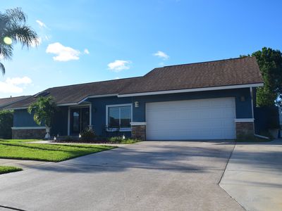
This is my actual childhood home. So many circles were biked around that driveway.
All through middle and high school - seven of my most formative years - I was bused nearly an hour away to go to school. The closest city bus stop was four miles from my house, and my parents hated driving me more than ten minutes away to play with friends, so I had extremely limited friendship options. We lived in a neighborhood with only about ten other homes on a block the size of one-square-mile. The memory of forcing myself up to each neighbor's door, knocking and asking "are there any kids here that want to play?" to amused adults who had nothing to offer but rejection still haunts me.
I was suffocating. I felt like a prisoner wherever I landed. I felt rejection and a deep loneliness which has stayed with me, affecting my ability to function at times. I would often refer to my hometown as a "black hole" from which I had to escape.

And escape I did. I moved to Portland in 2012 and my life was forever changed. Portland is so meticulously planned and the city is rife with civic engagement. Seriously, their comprehensive plan is the size of a fat encyclopedia. They started writing regulation and putting tracks in the ground forty years ago and it shows. I wanted to bring those design principles back with me to my beloved hometown of Tampa Bay, which is in dire need of some intentional urban planning.
For me, sustainable planning principles are not just about ensuring a decent quality of life for some people - they're about justice. Justice for lonely children who like me, are developing mental illnesses like depression and social anxiety out in the suburbs as a result of social isolation. Justice for those whose lives were not considered when roads were built and development approved throughout the past several hundred years. While I was in Portland, Trayvon Martin and Michael Brown were murdered, and the Black Lives Matter movement was born. I learned that racism - segregation, discrimination, and concentrated poverty - is built directly into the land. And it is our job today to do something about it.
I am studying urban planning, transportation/accessibility in particular, because I am working to dismantle systems of oppression that benefit certain individuals in America and keep others at a perpetual disadvantage.
Which Brings Me To The Netherlands
In America, especially in Florida and Tampa Bay, our built landscape is designed around individualistic and cost-prohibitive automobiles. While I'm in the Netherlands, I plan to pay special attention to the ways that ALL people are considered in the construction of their cities and transportation infrastructure. I will be taking notes on how non-automobile modes, such as trains, bikes, buses, and feet, are given equal or priority consideration in design, and how they coalesce into a complete, intuitively navigable system. I have heard that the key to success is mode separation, so one of my goals is to test this theory and observe how they achieve this separation of modes considering high-density space constraints.
I am particularly interested in how the Dutch make accommodations for the disabled members of their society, and if they have any race-based justice issues that are addressed through policy, regulation, and access. I wonder if Dutch neighborhoods are segregated as ours are, and if you can tell when you're in an under-served (read: poor or people-of-color) part of town.
Just like when I moved back to Tampa Bay from Portland with my head full of ideas about density, zoning, bike lanes and light rail infrastructure, I can't wait to bring more best practices back to my hometown.